23 feb – 5 mrt 2026
Waarom deze reis?
- Ontstaan en opbreken van Gondwana: hoe passen Afrika en Amerika aan elkaar?
- Charles Darwin ging u in 1836 voor
- Steentijd grotten = de oudste mensen
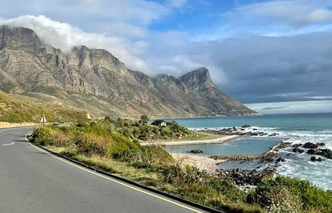
- Ruige gebergten afgewisseld met mediterrane landschappen
- De kleine en de grote Karoo incl Game drive voor de big five
- Langebaan fossielen park, maar ook Mesozoische en nog oudere fossielen
- Hét wijngebied van Zuid Afrika – verschillende terroirs: wijn en ondergrond
Helaas deze reis is vol. U kunt zich nog opgeven en wordt dan op de wachtlijst gezet.
Deze geologische excursie combineert de achtergrond van de zuidwestelijke Kaapprovincie, de kustmeren van de Gardenroute, het binnenland van de Klein Karoo, uitgestrekte vlaktes van de Grote Karoo woestijn, de westkust, intersecties van Cape Fold Belt-bergketens, met de evolutie en geologie van het uiteenvallen van de Gondwana plaat.
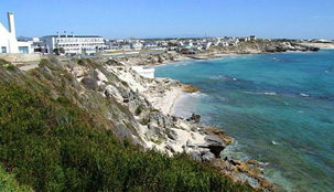
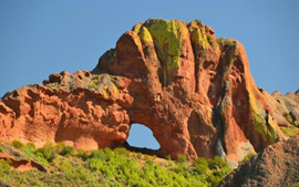
De tektonisch-sedimentaire geschiedenis van het pre-Kaapse basement, Kaapse en Onder-Karoo Supergroepen, en de Jura-Krijt bekkens, zijnde de equivalenten op het land van het offshore koolwaterstofhoudende Outeniqua-bekken, zullen deel uitmaken van de excursie. De ontwikkeling van deze bekkens tijdens het uiteenvallen van Gondwana, hun structurele setting, hun relatie met bestaande structurele trends in het basementgesteente, veranderingen in relatieve zeeniveau levels, drainageontwikkelingen en meer zullen worden besproken.
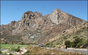
De daaropvolgende evolutie van de kustvlakte, de afwateringssystemen en de Plioceen – Pleistocene ondiepe mariene sedimenten, het eolische bedekkingsgesteente van de Bredasdorp Groep, dit alles gekoppeld aan diverse zeeniveaufluctuaties, zal worden onderzocht in Die Kelders, Arniston, De Hoop Nature Reserve, het Mossel Bay-gebied en het Langebaan Fossil Park.
Regional Geological Setting
Tekst: Jean Malan
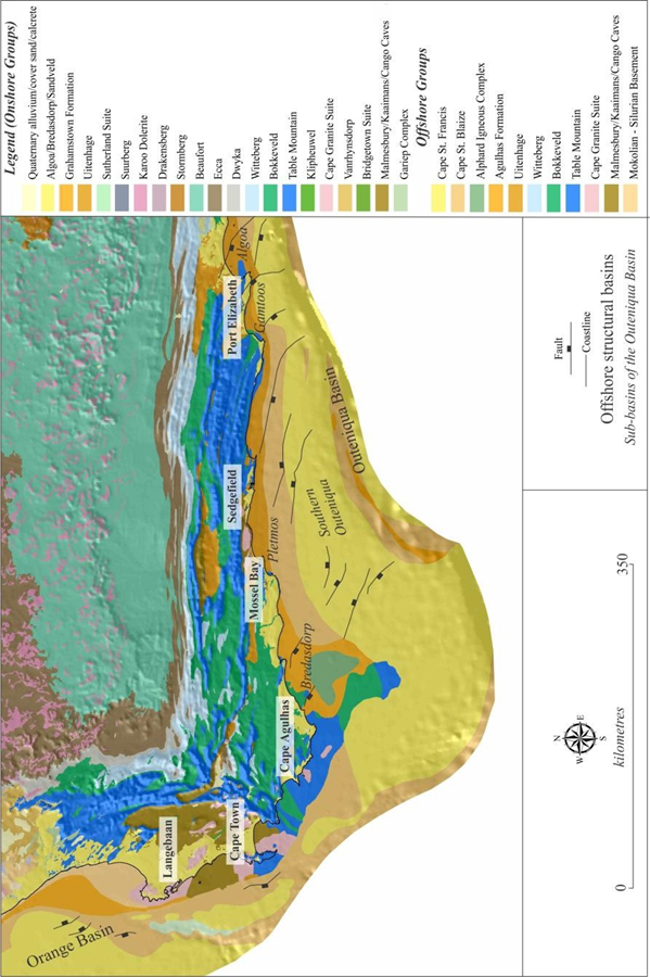
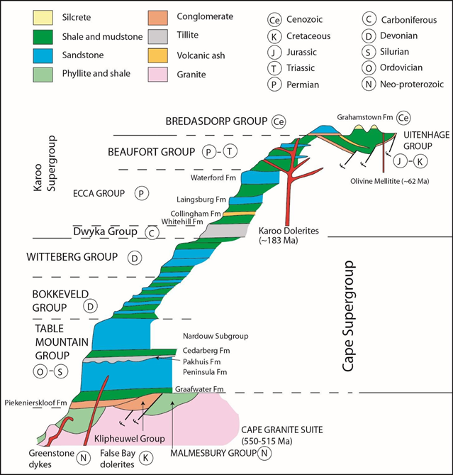
A simplified geological map of the southern part of South Africa is shown in Figure 1, while a generalized stratigraphic column of the geological units present in the western and southern Cape is depicted in Figure 2
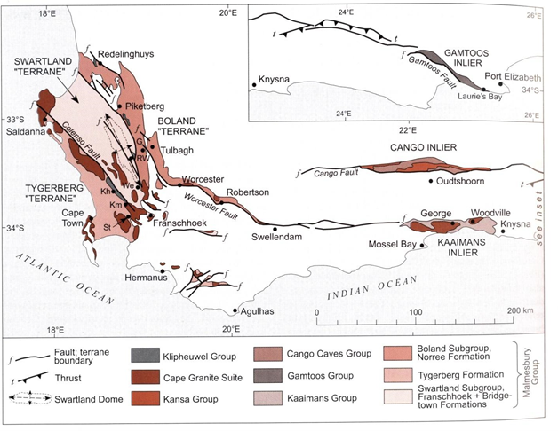
The oldest rocks or basement in this area are Neoproterozoic to Early Cambrian successions. Outcrops of these basement complexes (Saldania Belt) are mainly obscured by the cover sequences of the Cape and Karoo Supergroups. However, isolated exposures are found as inliers in the western and central parts of the Cape Fold Belt (Figure 4). These successions have been divided into four broad units comprising the Malmesbury, Cango Caves, Kaaimans and Gamtoos Groups. These poly-deformed units consist mainly of phyllites, fine grained greywackes, quartz-mica schist, limestones and occasional conglomerates. Sedimentation was mainly as deep-water mudstones, turbidites, shelf carbonates, deltaic and fluvial deposits.
These sediments were intruded by the syn- to post-orogenic Cape Granite Suite (550 – 515 Ma) which constitutes many batholiths and plutons in the Western Cape. Beautiful contact relationships between the basement and the granite are exposed at a coastal outcrop at Sea Point, Cape Town. This outcrop was also visited and described by Charles Darwin (1844) on his voyage around the world.
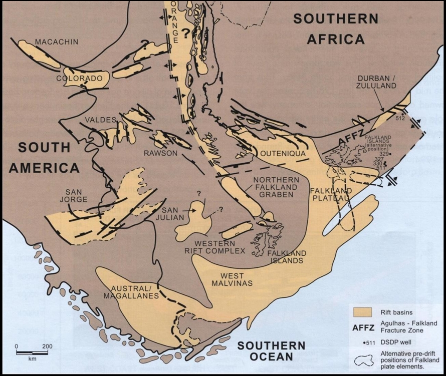
After upliftment and a prolonged periode of quite some erosion a new broad cratonic shelf evolved and experienced extensive subsidence and northward transgression by a marginal sea. This led to the accumulation of the Cape Supergroup, a southward-thickening clastic wedge approximately 6500m thick (Theron and Thamm, 1990). These sediments were deposited in a basin, the “Cape trough”, which developed as an aborted rift along the incipient plate boundaries of a triple junction situated between southern Africa, Antarctica and the Falkland Plateau (Tankard et al., 1982). See Figure 3.
The Cape Supergroup can be subdivided into three major lithostratigraphic units, the Table Mountain Group, the Bokkeveld Group and the Witteberg Group (Figure 2). The mountain ranges of the southwestern Cape are mainly built by the predominantly arenitic basal unit, the Table Mountain Group, which has in turn been subdivided into eight formations (Figure 2). One of these, the pelitic Cedarberg Formation has yielded a variety of brachipods and microfossils and more recently mucronaspidine trilobites, which clearly indicate a late Ordovician (Hirnantian) age.
The basal Piekenierskloof Formation was deposited in an elliptical basin with a northwesterly-trending long axis. This eminently rudaceous unit represents a southeastward-directed braid plain contiguous to high relief towards the northwest. Distally this braided alluvial sequence gradually graded into coarse-grained sandstones. According to Rust (1977) the overlying Graafwater Formation represents back-barrier tidal-flat, estuarine and shallow-subtidal sediments, which are transgressively overlain by the high-energy barrier and shelf arenites of the Peninsula Formation. Alternatively, other researchers visualize the deposition of the Graafwater and Peninsula sediments as a major braid plain system that prograded into a marine depository southwards, the Graafwater Formation representing the slowly aggrading, distal forerunner of the Peninsula braid plain. Various interfingering bioturbated beds attest to concurrent transgressive and regressive marine interludes. In the late Ordovician a wide braid plain and shallow-marine shelf, which extended up to Vanrhynsdorp, represented the Cape Basin.
An extensive Gondwana ice-sheet, centred in central Africa, bordered the basin to the north. At least two major glacial advances, with an interglacial stage, are recorded in the Pakhuis Formation. To the north the ice-sheet carved glacial pavements and roche moutonnees on the pre-Cape basement, but to the south the ice-sheet rested directly on unconsolidated Peninsula sand and created a characteristic zone of soft- sediment deformation structures, the so-called Glacial Fold Zone (Rust and Theron, 1964; Rust, 1967; 1973). The southerly palaeoslope during Peninsula time and other features relating to the fold geometry suggests that ice movement was from north to south. The overlying Cedarberg Formation, which forms a conspicuous marker horizon amidst the predominantly arenitic units, represents the regressional outwash stage of the Pakhuis ice sheets which developed with climatic amelioration. Only fine mud (Soom Shale Member) initially accumulated in the peripheral glacial lakes and shallow-marine embayments. The overlying Disa Siltstone Member exhibits progressive coarsening upward, while the presence of a marine fauna at various levels indicates the sequential glacio-eustatic rise of sea level.
In the Silurian, during persistent northward-progradation of the shoreline, the sediments of the Goudini and Skurweberg Formations, derived from a basement mainly composed of granitoids and gneisses, were deposited in a shallow open sea. A low mesotidal regime existed and sediments were extensively reworked by currents and wave action. Stunted barrier islands were separated by deep tidal inlets and thick, laterally continuous, tabular sand-bodies accumulated. Along the northern shore these sediments graded into extensive coastal plains criss-crossed by braided-river systems (Thamm and Johnson, 2006). The uppermost unit of the Table Mountain Group, the early Devonian Rietvlei Formation (Rust, 1967), was deposited in a wide shallow embayment open to the southeast and flanked by a mature low-gradient coastal plain.
An increased rate of downwarping, perhaps as a result of more active basin-margin faulting in the early Devonian (Emsian), resulted in rapid basin-wide deepening, marked northward advance of the shoreline and progression of the basal muddy Bokkeveld shelf facies across the Rietvlei sand–shoal deposits. The Bokkeveld Group is defined by its relatively subdued weathering in comparison to the over- and underlying resistant arenitic units. Its five arenitic formations give rise to hogsback topography but good exposures of the intervening six argillaceous formations are rare. The Emsian-Givetian Bokkeveld basin consisted of a linear southeast-trending intracratonic open-ended basin flanked by marginal shelves to the north and west, which gradually deepened into a southward sloping shelf. The pulsatory and tectonic nature of the Bokkeveld basin and provenance is reflected in the alternation of arenitic and politic units, which constitute five major sheet-like superimposed and corresponding genetic packages. These five, coarsening-upward cycles, feather out southwards into a relatively homogeneous mudstone-siltstone sequence. They represent successive southward advances of numerous, laterally coalescing, arcuate deltas along a mixed tidal-and wave-dominated lobate coastline, under the influence of repetitive regressions and transgressions.
The overlaying Witteberg sediments indicate overall shallowing of the basin during the Frasnian, when delta-front and delta-plain silts and muds accumulated. The Witteberg sediments indicate a gradual return to more extensive reworking of the deltaic sediments in shallower water and corresponding deposition of thicker, more continuous mature arenitic units. The Witteberg quartz arenites therefore originated as barrier and shore sands seaward of tidal flats. South- and eastwards the barrier, channel and mouth-bar sands thin and merge with delta-slope and shelf deposits.
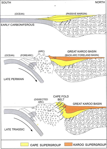
The end of deposition of the Cape Supergroup also mark a change in the transport direction of sediments, from mainly a northern source to also a southern (Atlantic) source that became more prominent with time (Figure 5). The Carboniferous glacial Dwyka Group forms the basal unit of the Karoo Supergroup, followed by the Ecca and Beaufort Groups which we will unfortunately not see on this excursion.
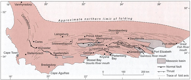
The Cape orogeny, which affected not only the sandstones and shales of the Cape Supergroup but also the older pre-Cape rocks and younger Karoo Supergroup strata, took place during the Late Permian and Early Triassic. While most of the Cape Basin (a passive continental margin?) was affected, only the southernmost part of the foreland Karoo Basin was involved, with the deformation dying out rapidly towards the north. The Cape Fold Belt probably extended much farther to the south where even more intense deformation may have taken place. The Cape Fold Belt is part of a much more extensive Gondwanide fold belt with similar sequences in the Falkland Islands, Argentina and Antarctica (Figure 3). Such a large-scale change from general subsidence and sedimentation to deformation and uplift is known as inversion, and is characteristic of the history of many large basins.
The Cape Fold Belt is conventially divided into a Western and Southern branch, which meet along a north- easterly striking zone of syntaxsis (Figure 6). The high mountain ranges in the southern and western Cape is mainly due to this fold belt. In the southern branch the fold intensity increases from north to south across strike of east-west trending folds, from upright folds to near isoclinal recumbent folds. The degree of thrusting increases co-commitently with the intensity of folding. Four paroxysms of deformation have been deduced on the basis of argon outgassing events recorded by pelitic cleavages. The first paroxysm occurred at 278 Ma, followed by the main phase at 258 Ma. The third cleavage formed at 247 Ma, while a final pulse produces kink bands or pressure solution cleavages at around 230 Ma (Söhnge and Hälbich, 1983).
PROGRAMMA
Reisafstand: Ongeveer 1.900 km, met de langste rit van 260 km en de kortste van 140 km in een luxe (mini)bus met chauffeur.
Verblijf: Kaapstad, Hermanus, Arniston, Herbertsdale, Knysna, Oudtshoorn, Matjiesfontain, Robertson, Langebaan zoals aangegeven op de kaart.
Hotels:
- V&A Waterfront Breakwater Lodge 2 nachten (Kaapstad),
- The Windsor (Hermanus),
- The Arniston Spa (Waenhuiskrans),
- The Point Hotel 2 nights (Mosselbaai),
- Oudtshoorn Inn, Lord Milner (Matjiesfontein),
- Montagu Country Hotel, Club Mykonos (Langebaan).
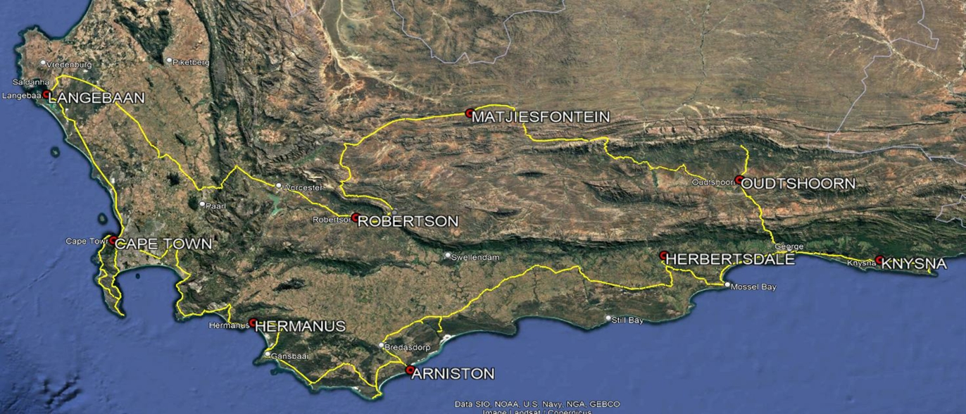
Route: Vanaf V&A Waterfront in Kaapstad gaan we langs de kust van het Kaapse Schiereiland, de Atlantische Oceaan en False Bay, in oostelijke richting langs de zuidkust en de kustvlaktes naar Gordon’s Bay, Hermanus, Kaap Agulhas, Mosselbaai, Sedgefield en Knysna met een korte terugkeer naar George om landinwaarts te gaan en het Outeniqua-gebergte over te steken (oost-west arm van de Cape Fold Belt, CFB) naar Oudtshoorn in de Kleine Karoo. Van hier uit gaan we naar het westen naar Calitzdorp, steken we de Huisrivier Pass over om door het Swartberg-gebergte (binnenste arm van de CFB) via Seweweekspoort over de vlaktes van de Grote Karoo naar Laingsburg te rijden, Matjiesfontein, via Die Koo naar Montagu via Cogmans Kloof Pass (syntaxis van de CFB) naar Worcester, en steken vervolgens de noordelijke arm van de CFB over via de historische Bain’s Kloof Pass naar de westkust en Langebaan Fossil Park, om langs de Atlantische kust naar Kaapstad terug te keren.
Dag 0: ma 23 feb Vertrek Schiphol
Dag 1: di 24 feb (180 km)
Locaties: Table Mountain, Kloofnek, Sea Point,Contact, Chapman’s Peak Drive, Cape, Peninsula, Cape Point, Bolder beach, Simons Town
We maken een rit langs de Tafelberg contour pad, Precambrium basement contact met Kaaps graniet zoals bezocht door Charles Darwin, Tafelberg Groep TMG stratigrafie en sedimentologie
Overnachting: Cape Town
Dag 2: wo 25 feb (150 km)
Locaties: Ervaar het wijnland van Stellenbosch, volg Clarens coastal drive naar Herald Porter Botanische Tuin, Betty’s Bay
Geologie & wijn, terroir, TMG kust gebergte, Kaap Fynbos met geologisch leerpad over 4,6 miljard jaar aardse geschiedenis, Estuaria
Overnachting : Hermanus
Dag 3: do 26 feb (180 km)
Locaties: De Kelders, Klipgat Grot (Midden & Laat hominoïden uit het stenen tijdperk), Strandveld Wijn, Kaap Agulhas zuidelijkste punt van Afrika ‘s
Plio-Pleistocene geologie, zee niveau terrassen, terroir van de kustvlakte en wijn, Waenhuiskrans grot
Overnachting: Arniston
Dag 4: vr 27 feb (220 km)
Locaties: Natuurgebied De Hoop, rivieroversteek per ponton, Riversdale naar Herbertsdale ’s
Ontdek de Bredasdorp Group afzettingen uit het Cenozoïcum als gevolg van Neogene zeespiegelveranderingen. Daarna rijden we door om enkele Devoon en Jura ontsluitingen te bekijken.
Overnachting : Gondwana Game Reserve (met Big-5 game drive: leeuw, olifant, buffel, neushoorn en luipaard).
Dag 5: za 28 feb (150 km)
Locaties: Herberstdale, Mossel Bay, Wildernis, Sedgefield
We rijden langs het merengebied van de Gardenroute, basement Kaaimans Group, TMG en Jura-Krijt ontsluitingen
Overnachting : Knysna
Dag 6: zo 1 mrt (150 km)
Locaties: George, Outeniqua Pass, Little Karoo, Cango caves
We kruisen de zuidelijke arm van de Cape Fold Belt CFB TMG-bergen aan de kust, verkennen het Jura Oudtshoorn Basin en de basement Kango Groep
Overnachting : Oudtshoorn
Dag 7: ma 2 mrt (260 km)
Locaties: Oudtshoorn, Red Stone Hills, Calitzdorp, Huisrivier Pass, Seweweeks Poort, Laingsburg, Great Karroo
Meer Jura, Calitzdorp haven en wijn terroir, basement, bovenliggend TMG; we rijden door een poort gesneden door het CFB in de Grote Karoo en verder naar Carboon-Perm Dwyka, Ecca gesteente
Overnachting : Matjiesfontein
Dag 8: di 3 mrt (200 km)
Locaties: Touwsrivier, Koo, Keisie, Montagu
Ordovicium-Devoon TMG en Bokkelved, syntaxis van de CFB, 62 Ma Olivijn melilitite (stollingsgesteente) plug, Calcrete terroir en wijn
Overnachting : Robertson
Dag 9: wo 4 mrt (260 km)
Locaties: Worcester, Bainskloof Pass, Wellington, West Coast Fossil Park
We volgen de Worcester-breuk en steken de noordelijke arm van de Cape Fold Belt over om de Mio-Pliocene geologie en fauna fossielen van de Westkust te bekijken.
Overnachting : Langebaan
Dag 10: do 5 mrt (140 km)
We keren terug naar Kaapstad via Melkbos, Blouberg met uitzichten op de beroemde Tafelberg
Nachtvlucht naar Amsterdam, vertrek 23:45
Dag 11: vr 6 mrt Aankomst Schiphol 10:40 uur
OVERIGE INFORMATIE
- De excursie wordt door Jean Malan in de Engelse taal gegeven vandaar dat de geologische beschrijving onder de Tab Geologie op deze site ook in het Engels is evenals de excursiegids.
- U koopt de vliegtickets op eigen risico. Als op 30 september 2025 duidelijk is dat er voldoende deelnemers zijn stellen wij voor om vervolgens de volgende vluchten te boeken :
Heen: op 23 februari met KLM economy class vlucht KL597 Amsterdam – Kaapstad 09:30 – 21:55
Terug: 05 maart met KL598 Kaapstad – Amsterdam 23:45 – 10:40 + 1 (dus aankomst op 6 maart) - U kunt ook met een andere en wellicht goedkopere vliegmaatschappij (bv British Airways met een stopover) van en naar Kaapstad vliegen. Alleen voor de genoemde vluchten wordt luchthaventransfer geregeld. Komt u met een ander vlucht of als u al in ZA bent dan moet u op 24 februari om 9:00 uur bij het Breakwater Lodge hotel zijn: daarvandaan start de rondreis.
- Mocht de reis om welke reden dan ook niet (kunnen) doorgaan, dan zal Georeizen de gemaakte kosten voor de vlucht niet kunnen restitueren. De betaalde reissom wordt in zo’n geval natuurlijk wel terugbetaald. Deze terugbetaling wordt gedekt door de collectieve reisverzekering van het Garantiefonds GGTO waarvoor een toeslag van € 9,- op uw reissom in rekening wordt gebracht.
- Een eigen annuleringsverzekering voor deze reis dekt alleen uw betaalde reiskosten als u zelf of een familielid ernstig ziek wordt, als gevolg waarvan u moet afhaken. Desondanks is het wel verstandig om een reis- en annuleringsverzekering met voldoende dekking af te sluiten voor deze reis.
- Uw paspoort moet minimaal 30 dagen geldig zijn bij binnenkomst. Nederlanders hebben geen visum nodig voor Zuid Afrika.
Heeft u wel belangstelling maar schikt de datum niet, of wilt u bijvoorbeeld met een eigen groep, klik dan hier.
REISINFORMATIE
Data: 23 februari 2026 – 5 maart 2026 (terug in NL 6 maart)
Begeleiding: Jean Malan – geologie & Paul van Olm – organisatie. Jean Malan is een geoscientist (Afrikaans/Engelstalig), lid van de Overberg Geoscientist Group
Reissom: € 2809,- pp (inclusief € 9,- Garantiefonds GGTO) prijswijzigingen voorbehouden
Vlucht: U moet zelf de vliegtickets aanschaffen. Koop/boek geen vliegreis voordat u van ons gehoord heeft dat de reis voldoende deelnemers heeft en ook echt doorgaat. Deadline is nu 30 september 2025. Voor meer informatie zie Tab OVERIGE INFORMATIE
Vervoer: Vervoer in Zuid Afrika per luxe touringcar met professionele chauffeur
Verblijf: Verblijf op basis van vol pension in alle hotels.
Inbegrepen:
- Alle toegangen tot te bezoeken bezienswaardigheden tijdens de excursie incl. Aquila Big Five Game Drive
- Begeleidings- en organisatiekosten
- Excursiegids (in het Engels) 50 p. wordt uitgereikt (?) in Kaapstad of als PDF verstrekt.
Niet inbegrepen:
- Vluchten
- Persoonlijke uitgaven
- Persoonlijke reis- en annuleringsverzekering.
Aantal deelnemers: 14 – 18